 button. If a
profile is on it will be drawn as a red line on the sky and objects that
fall below the profile are not drawn. Note that the rise and set times
reported elsewhere do not take into account this horizon.
button. If a
profile is on it will be drawn as a red line on the sky and objects that
fall below the profile are not drawn. Note that the rise and set times
reported elsewhere do not take into account this horizon.
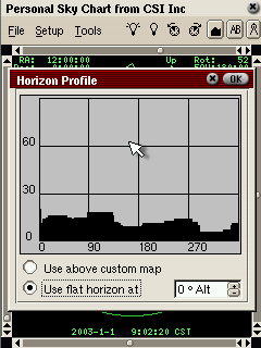
Setup -> Horizon
This controls how a local horizon profile is defined. Whether it is drawn is
determined by the Horizon toolbar button. If a
profile is on it will be drawn as a red line on the sky and objects that
fall below the profile are not drawn. Note that the rise and set times
reported elsewhere do not take into account this horizon.